
From collection Place
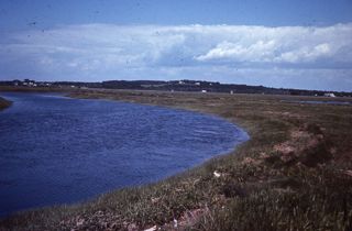
Scarborough Marsh is a 3,200-acre saltwater marsh. The main waterways in the marsh are the Libby River, Nonesuch River, Dunstan River, Scarborough River, Jones Creek, Mill Brook, Phillips Brook, Finnerd Brook, and Cascade Brook. There are many other minor creeks that feed the main waterways. The majority of the marsh is managed as a wildlife management area by the Maine Department of Inland Fisheries and Wildlife. Maine Audubon operates a nature center on Pine Point Road and provides canoes for use on the rivers. An observation tower is a short walk from the IF&W-maintained parking area off Manson Libby Road. The Eastern Trail, on right-of-way of the former Portland, Saco & Portsmouth Railroad, provides a path for walking, biking, cross-country skiing and bird watching. (The Eastern Trail is the southern Maine section of the East Coast Greenway). ("Scarborough Marsh" at Wikipedia: The Free Dictionary [https://en.wikipedia.org/wiki/Scarborough_Marsh : accessed 27 August 2025]). Scarborough Land Trust has supported and collaborated on land protection and marsh restoration projects associated with Scarborough Marsh, conducted its own marsh scientific research and supported scientific projects by university partners.
Related Items

